Search
Lucas Stamper, Hutchins, Robbie, Guo, Jinggang, West, Valerie


Download Publication ID:
Jinggang Guo, PhD, Forest Economist, LSU AgCenter
If you own timberland in Louisiana, chances are you’ve heard people talking about “carbon credits.” Some of your neighbors may already be enrolled. A forestry consultant may have mentioned it, or someone may have called you out of the blue. The talk can sound complicated, but the basics are not. Carbon contracts run for decades. Before signing one, talk to a forester, a Louisiana attorney, and a tax advisor.
As your trees grow, they pull carbon dioxide out of the air and lock it up in wood, branches, roots, and soil. One carbon credit stands for one metric ton of carbon dioxide stored or kept out of the atmosphere. Companies that release greenhouse gases — utilities, airlines, manufacturers — sometimes buy these credits to offset what they put out. When a landowner enrolls in a forestland program, the program sells credits on the landowner’s behalf and pays the landowner a share.
Here is the part that trips people up. A carbon program will not pay you just for having trees. It pays you for storing more carbon than you would have stored anyway. In practice, that almost always means agreeing to cut less timber, or cut it later, than you otherwise would have.
Setting up a carbon project on your own is expensive. Measuring the forest, getting the measurements independently verified, registering credits, and finding a buyer can run into tens of thousands of dollars before a single credit sells. For most family-sized tracts, that does not pencil out.
That is why carbon developers — often called “aggregators” — exist. They bundle many landowners’ properties into one larger project, cover the upfront costs, handle the paperwork, and sell the credits. In exchange, they keep a share of the revenue. Most programs charge nothing out of pocket. The developer’s cut varies, so before signing with anyone, ask directly how the revenue is split and get it in writing.
This model matters here in the South, where most forestlands are privately owned, often in tracts of a few hundred acres or less.
Based on public company materials and registry records as of early 2026, the four programs below are signing up or actively working with Louisiana landowners. Other developers operate in the South too, and details change. Confirm everything directly with any company before deciding.
These programs fall into two categories. Improved forest management programs pay landowners to keep existing forests standing and harvest less than they otherwise would. Reforestation programs pay landowners to plant new forests on former cropland. Minimum acreage, contract length, and payment structure can differ significantly between the two.
NativState, based in Conway, Arkansas with a Louisiana office in Monroe, works with existing forests: you keep your woods standing and agree to cut back on harvesting. As of early 2026, the company reports more than 700,000 acres enrolled across the South, over 650 landowner families, and more than $20 million paid to landowners since 2021. All projects carry third-party sustainable forestry certification (FSC, SFI, or ATFS), and credits run through the American Carbon Registry (ACR).
Two verified projects involve Louisiana land. ACR 848 (“Bottomland Forests of Louisiana Plains”) covers roughly 20,000 acres in northeast Louisiana with 19 landowning families. ACR 1015, verified in February 2026, covers more than 37,000 acres with 48 landowners, many of those acres in Louisiana. Both carry the Core Carbon Principles label — a quality standard from the Integrity Council for the Voluntary Carbon Market.
In July 2025, the French energy company TotalEnergies signed an agreement to buy credits from 13 NativState projects covering 247,000 acres across Louisiana, Arkansas, Mississippi, and Tennessee, involving more than 280 landowner families.
Credit prices have generally run $13 to $30 per ton. Contracts run 40 years, with a minimum enrollment somewhere in the 40- to 50-acre range (the website and marketing list different numbers — ask directly). A separate Forest Restoration track for converting non-forested land back to forest has a 20-acre minimum and a 60-year commitment.
LandYield, based in Chattanooga, Tennessee, uses satellite imagery, aircraft-based laser mapping (LiDAR), and forest inventory data to estimate carbon — which keeps costs low enough to serve smaller tracts. In mid-2025, LandYield bought the CORE Carbon platform from Finite Carbon outright. Its projects run through ACR, using a method built specifically for small family-owned forests.
The platform covers all 64 Louisiana parishes. Minimum is 40 acres, maximum 5,000. About 70 to 80 percent of your land needs to be timber that could be sold commercially; land under easements restricting commercial cutting may not be eligible. The 40-year contract bars commercial harvesting for the first 20 years, then allows harvest not exceeding forest growth for the remaining 20. Personal firewood, salvage cutting after a storm, and pest management are still allowed.
There is no upfront cost, payments come quarterly and based on independent reviews the first payment typically arrives within about five months of enrollment. The payment is fixed for the first three years, then moves with the market.
A few legal details matter. LandYield receives rights to the timber through a deed recorded against the property. If the land has a mortgage, the lender has to sign off. Leaving the contract early requires paying back the current value of all credits that have been issued from your land. The property can be sold, but only if the new owner agrees to take on the contract — otherwise the carbon obligation has to be bought out before the sale.
Background worth knowing: the CORE Carbon platform was originally built by Finite Carbon, which was majority-owned by the oil company BP from 2020 until February 2025, when Canadian firm Boreal Carbon Corporation acquired it. Some independent analysts have raised questions nationally about whether certain forest management programs overstate additional carbon storage. LandYield’s specific method is its own, and no fraud findings or regulatory actions have been made against it.
GreenTrees, owned by ACRE Investment Management in The Plains, Virginia, is a reforestation program. It plants trees on land that used to be farmed, turning it back into native bottomland hardwood forest in the Mississippi Alluvial Valley. If you already have standing timber, this program is not for you.
GreenTrees has reforested more than 140,000 acres across over 650 properties, planting more than 60 million trees of 27 or more native hardwood species. Louisiana landowners are among the participants. In 2022, it described as a record year, not a typical one — GreenTrees distributed $8.2 million to landowners, roughly $61 per acre. Future payments could be higher or lower.
The minimum is just 10 acres. Contracts run for 40 years, with a deed recorded on the enrolled acres. In July 2025, GreenTrees credits earned Core Carbon Principles approval. The program reports it has never had a “reversal” (a loss of stored carbon that has to be accounted for) and has set aside 1.2 million credits in ACR’s insurance buffer pool. About 95 percent of enrolled lands are more than 100 miles from the coast, which lowers hurricane risk across the portfolio.
Context worth asking about: a 2020 Bloomberg Green investigation raised questions about whether some GreenTrees enrollments involved land where trees had already been planted through federal conservation programs, which would affect the “extra carbon” calculation. GreenTrees said independent auditors verified compliance with registry rules, and no legal action followed. The 2025 Core Carbon Principles approval is a reasonable counterweight to the older concern.
Ducks Unlimited’ s Flyway Forests program operates in parts of Louisiana, Arkansas, Mississippi, Tennessee, and Missouri. Like GreenTrees, it is reforestation for agricultural land, not for existing forests. But carbon here is a funding mechanism rather than the main goal — DU’s primary mission is waterfowl habitat and bottomland biodiversity. If ducks and wildlife matter to you, this fits. If carbon payments are the main draw, the economics work differently here.
DU covers all site preparation, tree planting, and monitoring at no cost to the landowner. A DU biologist helps lay out which parts of the property to restore and which to keep for roads, food plots, or a future building site. The program received a $10 million U.S. Forest Service grant in 2024 and aims to restore at least 10,000 acres by 2030.
Minimum enrollment is 75 acres of cropland, grassland, or pasture, and the acres do not have to be connected. The land cannot have been cleared of trees in the last 10 years and cannot already be enrolled in a government-funded tree-planting program.
There are two payment options:
DU plants about 350 trees per acre using native bottomland hardwoods, with about half oaks. Easements, when chosen, are held by Wetlands America Trust (DU’s land-holding affiliate). Unlike the other three programs, the per-acre payments above come from conservation grants and easement funding, not carbon credit sales; carbon credits from this program are not expected to start generating until around 2030. Enrollment starts in October and closes in February, with limited slots. Contact: flywayforests@ducks.org.
Other developers — Forest Carbon Works, Finite Carbon (now under Boreal Carbon), Anew Climate — may work with Louisiana properties too but typically want larger acreages or have less documented activity in this state. A program not listed above is not necessarily a bad program; it just warrants the same homework as any of the four above.
This is the question every landowner asks, and there is no single answer. Payments depend on the type of forest, number of acres enrolled, which program is chosen, and what credits are selling for when yours get sold.
Reported payments across these programs vary widely — from about $10 per acre per year on the low end up to the $61-per-acre figure from GreenTrees’ 2022 record year. NativState’s credit prices of $13 to $30 per ton translate to different per-acre amounts depending on how much carbon your forest can hold. DU’s reforestation payments are a per-acre total, paid out over 20 or 40 years.
Think of carbon payments as supplemental income — extra money on top of timber, hunting leases, or whatever else your land is earning — not as a replacement for timber revenue. High-quality U.S. Forest credits have generally held a price premium over other types, and that premium has been growing, but the market still moves.
Every program is different, but some threads run through all of them:
The contract outlasts most of us. Forty years is a long time, and your heirs will inherit the restrictions along with the land. Louisiana’s inheritance and community property rules — including forced heirship, which guarantee certain descendants a share of an estate — can add complications when contracts stretch across decades and possibly multiple successions. A Louisiana attorney familiar with property and succession law can walk you through this before you sign.
Hurricanes happen. Hurricane Laura in 2020 alone damaged roughly 800,000 acres of Louisiana forest across 22 parishes. Carbon registries require programs to hold 10 to 20 percent of their credits in an insurance “buffer pool” for exactly this reason, and landowners generally are not personally on the hook for storm damage. But a bad storm can pause or reduce the credit income coming off your land, and a damaged forest may take 15 years or more to recover.
Leaving early costs money. Getting out of a contract early usually means repaying income already received, often with interest and fees, or paying the current value of all credits that have been issued from your land. Read the early termination clause very carefully — it is usually the clause that surprises people.
The tax picture is not settled. As of early 2026, the IRS has not issued specific guidance on forest carbon credit income. It is likely ordinary income, but the details are not nailed down. A carbon contract that heavily restricts harvesting could also affect how land is classified for Louisiana timberland property tax purposes. Talk to a tax advisor who understands timber.
Mineral rights and Louisiana law. If someone else owns an active mineral servitude on the land, the right to drill or extract, they may be able to clear trees for access, which can conflict with a carbon contract. Verify all mineral servitudes before enrolling and talk to a Louisiana attorney about your specific situation.
The market is voluntary and unregulated. Louisiana has no state forest carbon program and no state regulatory framework for these contracts. Everything happens in the private, voluntary market, which makes personal due diligence more important than it would be in a regulated program.
When sitting down with any program representative, the following questions tend to expose whether a deal is a good fit:
Get the answers in writing. If an answer is vague, that is an answer too.
Be cautious of any program that:
The real programs take time. Fast talk usually means something is being glossed over.
Talk to a professional forester, a Louisiana attorney familiar with property law, and a tax advisor who understands timber. A 40-year commitment is a decision that belongs to future generations of your family. The time and money spent on professional advice before signing up is small compared to the cost of discovering later that you signed something you did not fully understand.
Your forest may well be worth exploring for a carbon program. Just take the time to understand what you agree to before you agree to it.
Luke Stamper, PhD, Extension Wildlife Specialist, LSU AgCenter
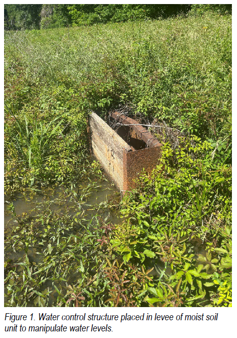
For wetland managers, moist-soil management involves the controlled drawdown and reflooding of wetlands to stimulate a favorable response from the native seedbank that produces seed-bearing plants and aquatic food resources valuable to waterfowl and other wildlife. A drawdown refers to the gradual removal of water from a management unit over time through water-control structures installed within moist-soil units. These structures vary in design and capacity, but flashboard risers (Figure 1) are commonly used. Flashboard risers allow managers to incrementally lower water levels by removing boards or gradually reflooding units by replacing them, providing precise control over the rate and timing of water movement. This controlled water removal enhances seedbank expression following wetland disturbance, while reflooding capability can be used strategically to suppress or manage undesirable plant communities.
Drawdowns are generally implemented across three primary temporal periods within the growing season: early, mid, and late. The early drawdown period encompasses approximately the first 45 days of the growing season, corresponding to mid-March through early May in Louisiana. The mid growing season drawdown typically begins in early May and extends into July and is often described as the second 45-day window of the growing season, though these timelines are not absolute and may overlap depending on site conditions and management objectives. The late drawdown period is recognized as mid-July and later and is commonly referred to as the final 90 days of the growing season.
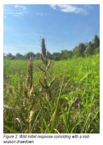
Each drawdown period is expected to yield a slightly different plant community response based on soil temperature, rainfall probability, and the rate of moisture loss through evaporation and evapotranspiration. Early drawdown periods often produce plant communities dominated by annual smartweeds, which are excellent seed producers and provide an important substrate for invertebrate production. Other species likely to proliferate during early drawdowns include spikerush (Eleocharis obtusa) and wild millets (Echinochloa spp.). Mid-season drawdowns tend to favor responses dominated by wild millets (Figure 2) and are commonly referred to as the “millet drawdown,” as these species are prolific seed producers that are readily consumed by waterfowl when available. The late drawdown period most often results in plant communities dominated by sprangletop (Leptochloa spp.), a species that provides valuable food, cover, and invertebrate substrate for migrating and wintering waterfowl. While each drawdown period has the potential to enhance food availability, managers should also recognize that undesirable plant responses can occur, particularly when drawdown timing, weather conditions, or hydrologic control are misaligned, and may require active mitigation to maintain desired plant communities (e.g., herbicide applications).
Identifying which drawdown period is most appropriate ultimately depends on clearly defined management goals and objectives, particularly as they relate to the timing and availability of food and cover for the suite of waterfowl species being targeted. For example, management strategies focused on early migrating species such as blue-winged teal often rely on earlier drawdowns to stimulate early successional vegetation and invertebrate production as quickly as possible to maintain throughout the summer. In contrast, management aimed at later-season dabbling ducks may benefit from delayed drawdowns that favor greater seed production and increased structural stability within the plant community. Regardless of the target species, successful moist-soil management requires managers to understand how drawdown timing interacts with water-control capabilities, soil moisture dynamics, plant community responses, and annual weather variability. By recognizing these interactions and aligning drawdown decisions with specific wildlife objectives, managers can use drawdowns as a flexible and intentional management tool rather than relying on a fixed calendar. This approach ultimately improves predictability, enhances ecological function, and increases wildlife use across seasons.
Robbie Hutchins, Area Forestry and Wildlife Agent, LSU AgCenter
Chinese tallow tree (Triadica sebifera) is one of the most aggressive invasive exotic trees currently threatening Louisiana’s forests, wetlands, and managed landscapes. Although originally introduced from Asia in the late 1700s for ornamental plantings and oil production, Chinese tallow has spread rapidly and now causes widespread ecological and management concerns across Louisiana.
Even though Chinese tallow tree can appear attractive in the fall, its ability to outcompete native vegetation makes it a serious problem for landowners and forest managers who are managing their forests for timber production and wildlife habitat.
Chinese tallow tree is known by several common names such as chicken tree, popcorn tree, and simply tallow tree. Chinese tallow trees are common along roadsides, fence lines, waterways, pastures, and forest edges. Key identification features include:
Chinese tallow tree grows quickly and produces large numbers of seeds, making it easy for the tree to spread into new areas. Chinese tallow tree seeds are spread by animals, like birds and squirrels, and by water. Once established, it grows faster than many native trees and forms dense stands that block sunlight from reaching the forest floor. Bottomland forests, wetlands, and disturbed areas are especially vulnerable to invasion by Chinese tallow tree.
Native wildlife depends on native plants. When Chinese tallow replaces native vegetation the food sources for the foundation or the food web, specifically insects and amphibians, decrease so their numbers also decrease. This reduction affects birds, reptiles, amphibians, and mammals that rely on these insects, amphibians, and native plants for survival.
Over time, Chinese tallow infestations can disrupt natural forest regeneration and succession, alter soil conditions, and reduce the overall health of forest ecosystems.
As with any invasive exotic species, early detection and control are critical. Small infestations of Chinese tallow trees are much easier and less expensive to manage than larger trees or well-established stands of trees.
Recommended control methods include:
Simply cutting Chinese tallow trees without using herbicide is not effective. Trees commonly resprout from cut stumps and damaged roots and will quickly return if not properly treated.
After treatment and removal, it is helpful to encourage the natural reestablishment of native plants or plant native species to prevent reinfestation of the area by Chinese tallow trees.
For detailed research based chemical control recommendations, the LSU AgCenter recommends consulting the following resources:
These publications provide general guidance only. Always read and follow current herbicide labels and consult your local LSU AgCenter Extension office before making applications.
Since the leaves of Chinese tallow tree provides a brilliant display of fall color, many people have planted them as a landscape tree not understanding the potential implications of the planting. The LSU AgCenter strongly discourages planting Chinese tallow in landscapes. Landowners seeking attractive alternatives that provide fall color in their landscape should consider planting native trees such as:
These species support wildlife, improve forest health, and do not pose invasive risks.
Invasive species management requires cooperation among landowners, land managers, and communities. Learning to identify Chinese tallow, managing infestations early, and planting native species are key steps in protecting Louisiana’s natural resources.
For assistance with identification or control recommendations, contact your local member of the LSU AgCenter’s Extension Forestry and Wildlife Team. Extension agents can provide research-based guidance tailored to your land and management goals.
Chinese tallow trees may look appealing, but their long-term impacts are costly. Acting now helps protect Louisiana forests, wildlife, and working lands for future generations.
Valerie West, Area Forestry Agent, LSU AgCenter
While some areas are more prone than others, wildfires can occur in any of the fifty U.S. states. Being prepared is key to protecting property from wildfire damage. Many homes lost to wildfires could have been spared or been salvageable had appropriate precautions been implemented. Outdoor spaces can play a vital role in reducing losses to wildfire by utilizing fire resistant building materials, creating defensible space, and taking strategic precautions like limiting fuel sources. The first steps to proactively creating a fire resilient landscape and enhancing defensibility for your property, neighborhood, or community are simple options that create a big impact.
Defensible space is a cost-effective strategy to prevent loss of buildings during wildfires by creating a buffer zone of at least 100-feet around a structure that's designed to slow or stop the spread across the landscape. This zone acts as a barrier when the amount of combustible vegetation, debris, and other materials that increase the fuel load are reduced or removed. Cohen (2008) defined distinct zones within defensible spaces (Figure 3) and discovered that homes within 100 feet of an active wildfire are susceptible to catching fire, even after the initial wildfire has passed, due to the effects of radiant heat. As a result, the tips outlined below for each zone can be implemented to reduce the risk of ignition.
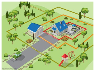
Figure 3. Diagram of ‘Defensible Space’ zones for a suburban home setting. Reproduced with permission from the National Fire Protection Association, copyright © 2019, NFPA, Quincy, MA. All rights reserved.
The zone within 5 feet of the home and the furthest attached exterior point or area should contain only non-combustible materials. This zone is the most vulnerable to embers from wildfire and where the homeowner needs to take immediate precautions, beginning with the house itself and moving into the immediately adjacent landscaping.
Whether building a new home or remodeling an existing structure, choosing to incorporate fire-resistant building materials into livable spaces can reduce the possibility of destruction and losses. Flammable items should be stored away from all livable areas. Maintain and provide easy access to potential water sources like hydrants, ponds, swimming pools, and wells to combat approaching wildfires in this zone and beyond. Other items that the homeowner can address within the immediate zone include:
The intermediate zone extends from five to thirty feet from the furthest exterior point of the home. In this area, a mixture of landscaping and hardscaping can provide firebreaks to slow fire progression and influence fire behavior on the property. The following actions can reduce disastrous outcomes from wildfires:
The extended zone ranges from the intermediate zone boundary to 100 feet or more. In this zone, property owners should plan their landscaping to slow fire progression. Fire damage can be reduced by keeping it on the ground, reducing the fuel load, and interrupting the path of the fire using non-flammable barriers. Some tips for enhancing the extended zones effectiveness include:
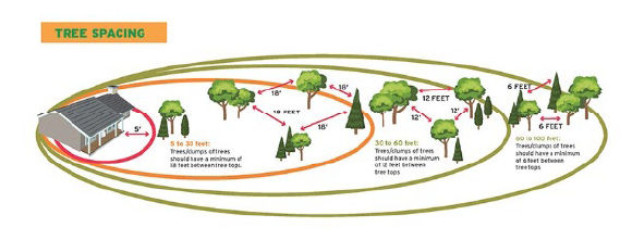
Figure 4 Example of tree placement in relation to the main home structure within the ‘Defensible Space’ zones. Crown spacing may need to be reduced to account for increasing slope, specific tree species, and other site-specific conditions. Reproduced with permission from the National Fire Protection Association, copyright © 2019, NFPA, Quincy, MA. All rights reserved.
Natural disasters such as wildfires affect all fifty states while recent shifts in weather patterns have created catastrophic wildfire scenarios, even in regions that have not previously experienced major wildfire seasons. Changes in weather patterns have extended the fire season in many regions from a summertime occurrence to a year-round risk. It is important to prepare for the possibility of wildfire no matter where you live. Preparing your property using defensible space techniques is a proactive step toward increasing wildfire resilience.
Upcoming Events
| Region | Title | Date | Contact |
|---|---|---|---|
| Northeast | Deer Management Field Day | June 12, 2026 | lstamper@agcenter.lsu.edu |
| Southeast | Tree Campus PLT Workshop | June 24-25, 2026 | vwest@agcenter.lsu.edu |
| Northwest | Forest Landowner Legal Workshop | July 28, 2026 | wwallace@agcenter.lsu.edu |
Contact your area agent/specialist for more information
| Name | Region | Title | Contact |
|---|---|---|---|
| Luke Stamper, PhD | Statewide | Extension Wildlife Specialist | lstamper@agcenter.lsu.edu |
| Jinggang Guo, PhD | Statewide | Forest Economist | jguo@agcenter.lsu.edu |
| Valerie West, PhD | Northwest | Extension Forestry/Wildlife Agent | vwest@agcenter.lsu.edu |
| Robbie Hutchins | Central/Southwest | Extension Forestry/Wildlife Agent | rhutchins@agcenter.lsu.edu |
| Whitney Wallace | Southeast | Extension Forestry/Wildlife Agent | wwallace@agcenter.lsu.edu |
For more information, contact your local Parish LSU AgCenter Office
Office Hours: Monday – Friday 8:00 a.m. – 4:30 p.m.
For the latest research-based information on just about anything, visit our website:
LSUAgCenter.com
The LSU AgCenter and LSU provide equal opportunities in programs and employment.


 TimberTales_Q2 - 2026pdf / 0.84MB